The Aral Sea Tragedy: Causes, Consequences, and Current Restoration Efforts
The Aral Sea disaster represents one of the most significant environmental catastrophes in modern history. Once the fourth-largest inland body of water globally, this massive lake has shrunk dramatically over the past six decades, transforming from a thriving ecosystem into a desert landscape. This comprehensive analysis examines the causes behind this ecological tragedy, its wide-ranging impacts, and current efforts to restore portions of this once-mighty sea.
Location and Geographic Context
The Aral Sea is situated in Central Asia, spanning two countries: Kazakhstan to the north and Uzbekistan to the south. Specifically, it lies within the Aktobe and Kyzylorda regions of Kazakhstan and the Karakalpakstan autonomous region of Uzbekistan. The name “Aral” derives from Mongolic and Turkic languages, roughly translating to “Sea of Islands,” referencing the more than 1,100 islands that once dotted its waters. The sea’s drainage basin extends across multiple countries, including Uzbekistan, Afghanistan, Iran, Kazakhstan, Kyrgyzstan, Tajikistan, and Turkmenistan.
Historical Significance
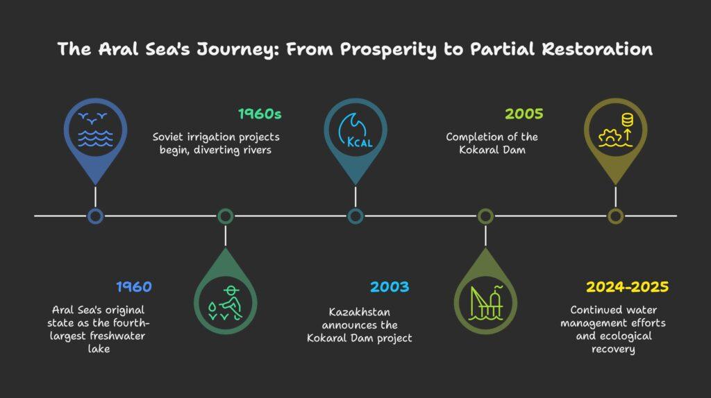
Before its decline, the Aral Sea covered approximately 68,000 square kilometers (26,300 square miles), making it the fourth-largest freshwater lake globally. It served as a vital resource for local communities, supporting robust fishing industries and moderating the regional climate. The sea maintained a stable water balance through inflow from the Amu Darya and Syr Darya rivers and evaporation.
Why Did the Aral Sea Dry Up?
The desiccation of the Aral Sea resulted from a combination of human activities and natural factors, though human intervention played the decisive role.
Soviet Irrigation Projects
The primary cause of the sea’s decline was the massive diversion of water from its tributary rivers for irrigation purposes. Beginning in the 1960s, the Soviet Union implemented extensive irrigation infrastructure to support agriculture, particularly cotton cultivation, which required substantial water resources. This involved constructing canals, dams, and reservoirs that diverted water from the Amu Darya and Syr Darya rivers, drastically reducing inflow to the Aral Sea.
By 1960, between 20 and 60 cubic kilometers of water annually was redirected to agricultural land instead of flowing into the Aral Sea. From 1961 to 1970, the sea’s level fell at an average rate of 20 cm per year, accelerating to 50-60 cm annually in the 1970s and 80-90 cm in the 1980s.
Inefficient Water Management
Compounding the problem was the inefficient use of diverted water. Poor irrigation practices resulted in significant water loss through leakage, evaporation, and inadequate canal maintenance. The mismanagement of water resources not only reduced the volume reaching the Aral Sea but also led to soil salinization and degradation in agricultural areas.
Climatic Factors
While human activities were the primary drivers, natural climatic variations also contributed to the disaster. The region experienced periodic droughts, which further decreased river flows and compounded the effects of water diversion. The Aral Sea region’s arid and semi-arid climate made it particularly vulnerable to these compounding factors.
Soviet Decision-Making and Environmental Disregard
The Soviet Union’s prioritization of agricultural expansion over environmental preservation directly led to the Aral Sea catastrophe. This was not an unforeseen consequence but rather an accepted outcome of economic planning.
Deliberate Sacrifice
Soviet authorities were aware of the environmental consequences their irrigation projects would have on the Aral Sea. As early as 1964, Aleksandr Asarin at the Hydroproject Institute acknowledged that the lake was doomed, explaining, “It was part of the five-year plans, approved by the council of ministers and the Politburo. Nobody on a lower level would dare to say a word contradicting those plans, even if it was the fate of the Aral Sea”.
Economic Priorities
Despite the Aral Sea’s fishing industry employing approximately 40,000 people and producing one-sixth of the Soviet Union’s entire fish catch, planners considered the water to be “wasted” in the sea when it could be used for expanding cotton production. This economic calculation disregarded long-term environmental impacts and local communities’ livelihoods.
Why Did the Aral Sea Become Salty?
The increasing salinity of the Aral Sea, which ultimately proved fatal to most of its ecosystem, resulted from several interconnected factors.
Endorheic Nature and Water Balance Disruption
The Aral Sea is an endorheic basin, meaning it has no outflow to external bodies of water. In such closed systems, salts and minerals carried by inflowing rivers accumulate over time. Historically, a balance existed between freshwater inflow and evaporation, maintaining stable salinity levels. When water diversion disrupted this balance, the concentration of salts increased dramatically as the sea volume decreased.
Historical Marine Connection
The Aral Sea was once part of the larger Paratethys Sea, which connected to the Mediterranean. This marine heritage contributed to its baseline salinity, which became increasingly concentrated as the water volume diminished. Unlike freshwater lakes formed from glacial meltwater (such as the North American Great Lakes), the Aral Sea retained these marine characteristics.
Human Impact and Environmental Consequences
The desiccation of the Aral Sea has triggered a cascade of environmental problems, creating what is often referred to as “the Aral Sea Syndrome.”
Ecosystem Collapse
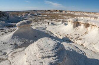
The Aral Sea is considered a textbook example of ecosystem collapse. By 2007, it had lost approximately 90% of its original volume, splitting into several smaller, highly saline bodies of water. As the sea receded, it exposed vast areas of the former seabed, creating a new desert called the Aralkum.
Toxic Dust Storms
The exposed seabed became a major source of sand and dust storms (SDS). Long-term dust analyses between 2003 and 2012 identified the deserts Karakum, Kyzylkum, and the new desert Aralkum as the main source areas for these storms in the Turan Lowlands. These storms carry salt, pesticides, fertilizers, and industrial pollutants, creating serious health and agricultural problems across the region.
Pollution Concentration
As the sea shrank, concentrations of pollutants rose dramatically both in the remaining water and in the dry beds. Industrial pollution resulted in PCB and heavy-metal contamination, while agricultural runoff contributed pesticides and fertilizers. Of particular concern was the former weapons testing site on Vozrozhdeniya Island (Renaissance Island), which was used for biological weapons testing until 1993 and remains contaminated with anthrax, plague, and tularemia.
Climate Change
The loss of the Aral Sea has altered regional climate patterns. The sea once moderated the local climate through humidification, regulation of thermal energy, and peri-winter albedo effects. Its disappearance has led to more extreme temperatures (broadening the annual temperature range by 4 to 12°C) and increased dust storms in the region.
Impact on Flora and Fauna
Fisheries Collapse
The Aral Sea’s fishing industry was completely devastated by the ecological changes. By the 1980s, commercial harvests had become unsustainable, and by 1987, commercial fishing had ceased entirely. The increasing salinity eliminated 19 of the 20 native fish species. Only flounder could initially survive the high-salinity levels, but even they were eventually killed off in the South Aral by the late 1990s as salinity continued to rise.
Economic and Social Disruption
Fishing towns along the original shores became “ship graveyards” as the water receded. Aral, once the main fishing port, is now about 15 kilometers from the sea and has experienced dramatic population decline. The town of Moynaq in Uzbekistan, which had a thriving harbor and fishing industry employing about 30,000 people, now lies 30-90 kilometers from the shore.
Additionally, the muskrat-trapping industry in the deltas of the Amu Darya and Syr Darya, which once yielded as many as 500,000 pelts annually, was completely destroyed.
The Aral Sea’s Physical Characteristics
Depth Variations
The Aral Sea’s depth has varied considerably over time and across different sections:
- Maximum depth (1989): 102 meters (335 feet)
- North Aral maximum depth (2008): 42 meters (138 feet)
- South Aral maximum depth (2005): 37-40 meters (121-131 feet)
- North Aral average depth (2007): 8.7 meters (29 feet)
- South Aral average depth (2005): 14-15 meters (46-49 feet)
Surface Area Changes
The sea’s surface area has dramatically decreased over time:
- Original surface area (1960): 68,000 square kilometers (26,300 square miles)
- Two lakes phase (1998): 28,687 square kilometers (11,076 square miles)
- Four lakes phase (2004): 17,160 square kilometers (6,626 square miles)
- North Aral (2008): 3,300 square kilometers (1,270 square miles)
- South Aral (2005): 3,500 square kilometers (1,350 square miles)
Restoration Efforts and Current Status
While complete restoration of the Aral Sea to its pre-1960 state is considered impossible, significant efforts have been made to revitalize portions of the sea, particularly the North Aral.
The Kokaral Dam
The most successful restoration project has been in the North Aral Sea, led by Kazakhstan:
- In October 2003, the Kazakh government announced a plan to build Dike Kokaral, a concrete dam separating the North and South Aral Sea
- The dam was completed in August 2005, preventing water from flowing out of the North Aral into the larger South Aral basin
- Since completion, the water level of the North Aral has risen significantly, and its salinity has decreased
- The dam caused the North Aral’s water level to rise from less than 30 meters to 38 meters
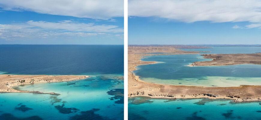
Ecological Recovery
The restoration efforts have yielded promising ecological results:
- Economically significant stocks of fish have returned to the North Aral
- Average salinity dropped from 30 grams to 8 grams per liter, enabling the return of almost 24 freshwater species
- The improved water conditions have reportedly given rise to long-absent rain clouds and possible microclimate changes
Current Status (2024-2025)
Recent data shows continued improvement in the North Aral Sea:
- Between October 2024 and January 2025, over one billion cubic meters of water were directed to the Northern Aral Sea
- Thanks to agreements with Central Asian partners, an additional 1.6 billion cubic meters of water will be directed to the Northern Aral by the end of March 2025
- As of 2024, the water volume of the North Aral Sea is 21.4 cubic kilometers
- The Northern Aral Sea now holds over 22 billion cubic meters of water, compared to 18.9 billion at the start of 2022
- Projections estimate this volume will reach 23.4 billion by the end of 2025 and 27 billion by 2030
Regional Differences in Restoration Approach
There are notable differences in how Kazakhstan and Uzbekistan approach restoration:
- Kazakhstan has actively worked to restore the North Aral Sea
- Uzbekistan has shown less interest in restoring the southern portion
- Some commenters suggest Uzbekistan has economic incentives not to restore their side, as they may extract oil and gas from the Aral’s shelf
Future Prospects and Challenges
Rehabilitation of the Dry Seabed
Efforts to mitigate the negative impacts of the exposed seabed include:
- On June 15, 2021, Kazakhstan announced plans to plant saxaul trees on one million hectares of the drained bottom of the Aral Sea to reduce dust storms
- Research on growing halophytic plants in the saline soils using various technologies, including the “pipe method” which showed 1.5 times higher efficiency than conventional methods
- Cartographic work to create detailed maps of the dry seabed, showing relief, soil types, and vegetation to monitor changes and develop environmental stabilization measures
Water Management Improvements
Addressing the root causes of the disaster requires improved water management:
- Turkmenistan has announced plans for a mega project to put concrete along the length of the Karakum Canal, which could significantly reduce water loss (approximately 70% of canal water is currently lost to the desert)
- Repairs and improvements to irrigation works on the Syr Darya have increased its water flow
- Diplomatic efforts between Central Asian countries have resulted in water redistribution agreements that benefit the North Aral Sea
Conclusion
The Aral Sea disaster represents one of the most dramatic environmental catastrophes of the modern era, primarily resulting from human mismanagement of natural resources. While complete restoration is unlikely, the partial recovery of the North Aral Sea demonstrates that ecological rehabilitation is possible with proper management and international cooperation.
The ongoing restoration efforts in Kazakhstan offer hope that at least portions of this once-mighty inland sea can be preserved for future generations. However, the massive environmental, economic, and health impacts on the region serve as a stark reminder of the consequences of prioritizing short-term economic gain over environmental sustainability.
The Aral Sea’s story continues to evolve, with recent developments showing promising signs of recovery in some areas while other portions remain desert. This complex situation underscores the need for continued international cooperation, sustainable water management practices, and innovative approaches to environmental restoration in addressing what remains one of the world’s most pressing ecological challenges.